


Penrith City: Strengthening Community Resilience with Data
Resilience is our ability to cope through tough times and emergencies, including natural disasters. It can be defined as the capacity of individuals, communities, institutions, businesses, and systems within a city to survive, adapt, and thrive in the face of chronic stresses and acute shocks. For Penrith City, resilience is not just about responding to emergencies-it is about proactively understanding risks and taking steps to mitigate them.
To support these efforts, the Penrith Resilience Mapping Tool was developed as part of the Resilient Penrith Action Plan 2021-2030. This tool enables the local government and community to assess vulnerabilities, prepare for environmental risks, and develop more effective strategies for long-term sustainability.
How it works
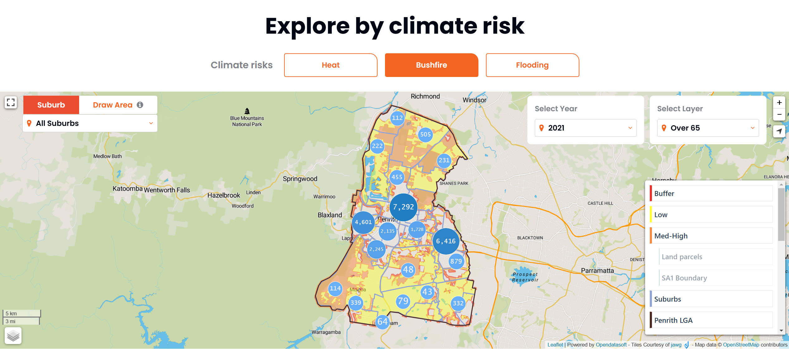
The Penrith Resilience Mapping Tool provides a comprehensive approach to resilience planning, focusing on three major climate-related risks: heat, bushfires, and flooding. Through an interactive digital platform, the tool allows council's planning staffs to analyse different layers of information.
Identifying Climate Risks - The tool enables council's planning staffs to visualise and analyse which areas of Penrith are most affected by extreme weather conditions. By selecting different climate risk categories, such as extreme heat, bushfire, or flooding, planners can see which locations are more exposed and assess their potential impact.
Assessing Vulnerability - The tool goes beyond mapping risks by providing insights into community vulnerabilities. By overlaying ABS datasets, it identifies which populations are more likely to be affected based on socio-economic and demographic factors. This includes:
-
Elderly residents (aged 65 and over)
-
People living alone
-
Households without access to a private vehicle
-
Aboriginal and Torres Strait Islander populations
-
Single-parent families with young children
-
Individuals requiring assistance
-
Residents who are not fluent in English
-
Total number of households in a selected area
Penrith Resilience Mapping Tool
Example: Flood risk evaluation and community resilience planning
Designed for detailed, location-specific analysis, the platform allows teams to zoom in on specific areas and assess various climate risk factors. By integrating land parcel data with demographic insights, it helps identify high-risk groups and improve disaster preparedness strategies. The following example focuses on flood risk assessment.
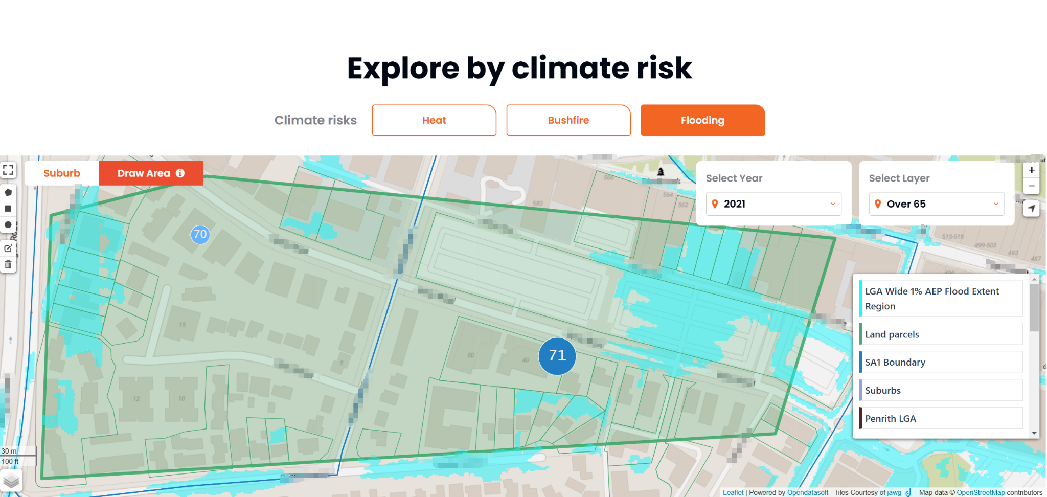
Step 1: Selecting the Analysis Area
In the mapping interface, the "Draw Area" tool was used to define a flood-prone zone near a river. The selected area was highlighted, with blue shading indicating potential flood impact zones. Additionally, the "Over 65" data layer was activated to assess the distribution of older residents in the area.
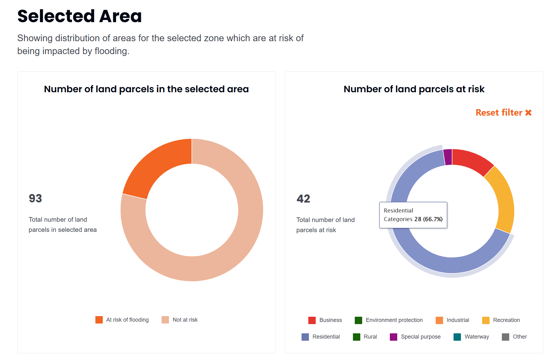
Step 2: Assessing flood-affected land parcels
Once the area was selected, the tool generated key land data, revealing that:
-
The area contains 93 land parcels.
-
42 parcels (around 45 percent) are exposed to flooding.
A breakdown of the affected parcels shows that:
-
66.7 percent are residential properties, indicating a potential risk to housing and community infrastructure.
-
The remaining affected parcels include commercial, industrial, and environmental protection zones.
This analysis helps determine risk exposure across different land uses, supporting better-informed disaster mitigation planning.
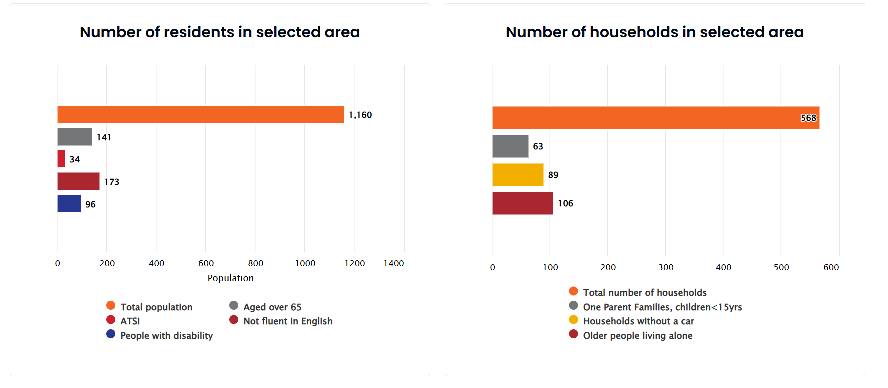
Step 3: Identifying high-risk populations
Beyond land use, the tool also provides insights into demographic characteristics, helping teams identify vulnerable populations. Key findings include:
-
The selected area has a population of 1,160, with 141 residents aged over 65.
-
173 individuals have limited English proficiency, which may impact their ability to receive and respond to emergency warnings.
-
106 households consist of older people living alone, who may face challenges evacuating during a flood.
-
89 households do not have access to a car, increasing evacuation difficulties.
This example demonstrates how the tool enables precise flood risk assessment by combining land parcel exposure with demographic insights. By identifying vulnerable areas and populations, council's planning staffs can make informed decisions to enhance disaster preparedness and response planning.
Supporting Climate Adaptation and Community Resilience
Beyond immediate risk assessment, the tool plays a critical role in long-term resilience planning by offering precise, location-specific insights. It helps teams prioritise infrastructure improvements, resource allocation, and risk mitigation strategies based on data-driven assessments.
By identifying high-risk areas and vulnerable populations, the tool ensures that climate adaptation efforts are both targeted and proactive. This allows planning teams to develop more effective disaster response strategies and support long-term resilience against extreme weather events.
If you want to learn more about our services, check our get inspired page and case studies. For tailored solutions from our experts, please contact us.